
Rides in our area - help yourself!
 |
 |
These rides are centred in Penrith and stem from 2015 when we - as a club -put together day rides for the CTC Holiday Birthday Rides that were held that year at Newton Rigg College near Penrith. Though they are almost entirely accurate and represent a great deal of checking and are supported by gps files and route cards we cannot take any responsibility for their accuracy or for the safety of riders who follow them. That said I hope you enjoy them, they were well received at the time and show a good cross-section of what is available in the area
The 25 rides vary in length from 10mi to over 80mi and are itemised below. There are links to .gpx files to transfer to your GPS and route cards with reference to a 'Gazetteer' with lots of interesting local information. OK they're not a glossy pamphlet issued by the tourist board but there is plenty of information to help you follow the route(who knows they might be interested). All routes start from Newton Rigg College on the West side of Penrith at OS NY492310
Note - Saving gpx files and transfering them to your GPS device is sometimes complicated but you basically need to right-click on the link to Save As../Download link as../Save link as.. and then choose where to put the file. When you have downloaded it to your computer you can move it into the folder GARMIN/NewFiles on your device. With luck it will then appear in the 'Tracks' , 'Routes' or 'Courses' menu.
A Routes (around 70 -80mi)
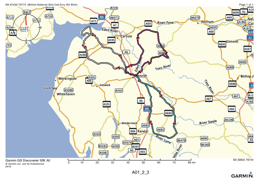
A01 - to Anthorne(S Solway Coast) and back. (77mi 906m ascent)
Routcard
Map
GPX file
A02 - To the edge of the Yorkshire Dales - great views (80mi 1277m ascent)
Routecard
Map
GPX file
A03 - Alston via Hartside returning via upper S Tyne and along the fellside (73mi 1590m ascent)
Routecard
Map
GPX file
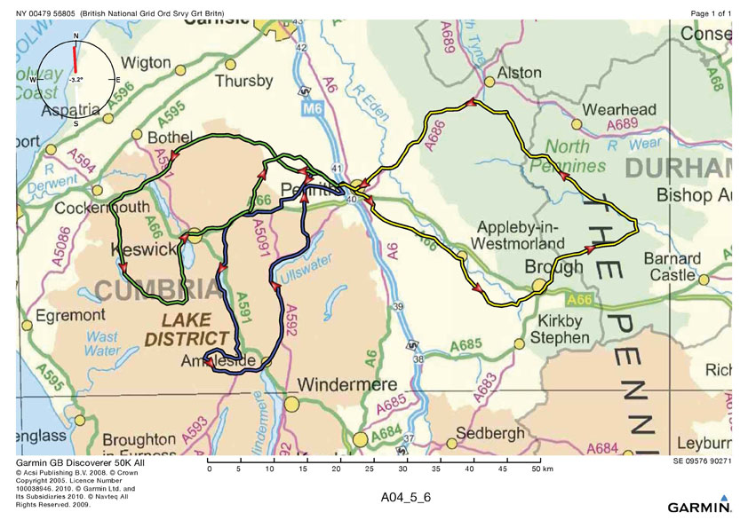
A04 - Dunmail Raise, Red Bank, Blea Tarn, The Struggle up Kirkstone! (69mi 1952m ascent)
Routecard
Map
GPX file
A05 - Alston, Middleton in Teesdale.(Summer weekends lots of motorcycles! 83mi 2216m ascent)
Routecard
Map
GPX file
A06 - Classic Lakes views Northern Fells, Honister, return through Keswick (72mi 2123m ascent)
Routecard
Map
GPX file
B Routes (around 60mi)
B01 - Fellside to Appleby returning through pretty valleys S of A6 (60mi 1143m of ascent)
Routecard
Map
GPX file
B02 - Lowther Orton Newbiggin on Lune and back (55mi 1010m ascent)
Routecard
Map
GPX file
B03 - Haweswater and back by the Eden Valley (59mi 1222m ascent)
Routecard
Map
GPX file
B04 - 'Back o' Skidder' Around the Skiddaw massif (50mi 1020m ascent)
Routecard
Map NOTE - Due to flood damage the route between Keswick and Threlkeld is via the Stone Circle
GPX file
B05 - To Carlisle and back along the Caldew cycleway (54mi 645m ascent)
Routecard
Map
GPX file
B06 - To the Solway and back via Caldbeck and Wigton (61mi 840m of ascent)
Routecard
Map
GPX file
C Routes (around 30 - 40mi)
C01 - Lovely views of the Eden valley E of Penrith - some hills!(30mi 396m ascent)
Routecard
Map
GPX file
C02 - Out via Mungrisdale return via Aira Force Ullswater and Pooley Bridge (40mi 877m ascent)
Routecard
Map
GPXfile
C03 - Down the Eden and back quite lumpy (31mi 814m ascent)
Routecard
Map
GPXfile
C04 - Around the fellside to Armathwaite returning through Calthwaite (41mi 827m ascent)
Routecard
Map
GPXfile
C05 - A route to Caldbeck NW of Penrith giving extensive views of the fells (34mi 660m ascent)
Routecard
Map
GPXfile
D Routes (around 10 - 20mi)
D01 - Countess Pillar 10mi
Routecard
Map
GPXfile
D02 - Newbiggin Stainton Rheged 11mi
Routecard
Map
GPXfile
D03 - Lowther, Abbot Lodge Jersey Ice cream Farm, Birds of Prey Centre 17mi
Routecard
Map
GPXfile
D04 - Plumpton and UpFront Gallery and cafe 16mi
Routecard
Map
GPXfile
D05 - Pooley Bridge and Brougham Castle 20mi
Routecard
Map
GPXfile
D06 - Villages W of Penrith 18mi
Routecard
Map
GPXfile
D07 - Long meg Kirkoswald and Lazonby 22mi
Routecard
Map
GPXfile
Gazetteer file Informative notes on many places on the rides!